Using Point Cloud to Survey a Lost Train
Recently, Bury Associates were given a very interesting yet unusual task to perform.
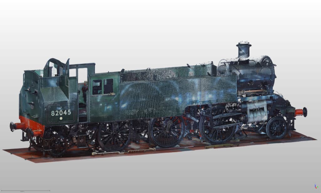
The story begins in January, when we were approached by a volunteer at Severn Valley Railway. Over email, they explained their project, begun in the late 1990s, to rebuild the lost 8205 steam train using only a set of blueprints.

Funded by enthusiasts, the initiative is fuelled by a hope that adding to the existing fleet of BR Standard locomotives could improve their longevity.
So, where do we come in? At the stage Bury Associates were contacted, the organisation were preparing the train to fit the boiler, but first they needed to ensure the dimensions would allow for its installation. Accordingly, we commenced laser scanning the train, creating a point cloud which provides an exact 3D representation of the model in its half-built state.
Impressively, the train pictured has been entirely built by volunteers at the organisation.

What is Laser Scanning?
Laser scanning is a method of surveying structures that revolutionised the process of data collection. Involving the emission of tiny beams of light to obtain precise coordinates, laser scanning utilises a technology known as LiDAR. The non-invasive process is ideal for surveys of delicate heritage structures or on inaccessible, even dangerous sites.
LiDAR: Facilitating Precision in Data Capture
Short for Light Detection and Ranging technology, LiDAR describes the process by which electromagnetic waves of radiation record the precise distances between elements. Applied to construction, this revolutionary method allows surveyors to take highly accurate measurements of a site. Removing the potential for human error, the data collected from LiDAR equipment is configured into what is known as a point cloud, ready for modelling in 3D.

Photogrammetry - Realistic Interpretations of Sites
Alongside LiDAR, surveyors often utilise photogrammetry when compiling data for a point cloud. This process involves taking a set of photographs from different angles, in order to calculate its dimensions and generate a 3D model using triangulation. The advantages of photogrammetry are its ability to display a photorealistic representation, including aspects like colour, texture, and shape.
Point Clouds - Comprehensive Data
Point clouds are a collection of data points in a 3D coordinate system, with each point corresponding to a specific location in 3D space and representing a tiny portion of the object or area being scanned. In addition to the spatial coordinates of structures, point clouds can also store colour and intensity values for each point. As such, the 3D models created are accurate not only in form but also in appearance.

Data-processing
Point clouds are integrated with Building Information Modelling (BIM) software, such as Autodesk Revit, ArchiCAD, Vectorworks, Briscad BIM, Tekla, or Bentley Microstation. This process allows architects and engineers to lay new designs over the scanned data, ensuring that their BIM models align perfectly with the actual physical dimensions of the site.
Laser Scanning for Measured Buildings Surveys
The most common application of laser scanning to a point cloud at Bury Associates is for measured building surveys.
In the construction industry, measured building survey services are required for ensuring projects are specified to correct dimensions. The building is laser scanned and the resulting point cloud data is transformed into a 3D model compatible with Building Information Modelling (BIM) software, When planning an extension or renovating a property, having access to accurate data is critical.
We provide our services to interior designers, architects, engineers, and many other professionals involved at various stages of the construction process.

We wish Severn Valley Railway all the best as they continue with their project, and implore anyone else with unusual requirements to get in touch! We will be more than happy to help!
We can provide your Laser Survey
Steve Bury is the Managing Director of Bury Associates, a land and measured building survey company based in the UK. With over 40 years of experience in surveying, Steve Bury established Bury Associates in 1997 to combine the provision of high quality digital surveys with exceptional customer service. Steve has also designed software applications for measuring buildings to automatically create survey drawings.