Why Combine a Topographical and Underground Utilities Survey
In this article, I will explain why a topographical survey should be combined with an underground utilities trace to obtain the most comprehensive portrait of your site.

As I expounded in my post on what is a topographical survey, carrying out a detailed scan prior to development on the site is crucial to the success of a construction project.
Unaware of the necessity of mapping underground utilities, developers may simply rely on a topographic survey to locate surface features. Such a decision neglects to appreciate the hefty financial costs, not to mention dangers, associated with damaging underground services.
What is an Underground Services Trace?
An underground services survey maps the network of utilities channels running below the surface of a site. Using specialist technology and equipment, surveyors can detect:
- Underground pipes, cables, ducts, and drainage
- Gas pipes, water mains, electric cables, and heating systems
- Fibre optics
- Telecommunications
- Foul water sewers
- Surface level drainage
Vital to the design phase of construction projects, a comprehensive survey tracks the position, depth, and route of underground services. Through their use of non-invasive techniques, highly-skilled surveyors can gather a clear insight into the underground layout without the need for excavation. This minimises potential damage to the existing infrastructure. Underground utilities tracing obtains information that is at once crucial for safeguarding workers on-site and avoiding costly disruptions. It also helps planners to make informed decisions about the design of new infrastructure. An assessment of compatibility with existing underground services is made possible only through a survey.
Why is an Underground Services Trace Important?
Failing to commission an underground services trace can have expensive ramifications. Like all surveys at Bury Associates, our tracing of underground utilities aims to provide the utmost level of detail, so that our clients can avoid any nasty surprises once work on the site begins. Ignorance of a site's underground layout can lead to accidental damages to subsurface infrastructure, creating costly delays and rework. A thorough survey helps project managers plan the construction process effectively.
Surveying underground utilities is also important for legal compliance. In the UK, there are specific regulations and practices that require developers to protect existing underground services during construction projects. By conducting a thorough survey and including an underground services trace, companies can stay compliant with these regulations and avoid potential legal issues.
Most importantly, ensuring an understanding of the location and depth of underground services helps mitigate risks to both construction workers and the public. With a comprehensive survey, project managers can develop appropriate risks mitigation strategies and contingency plans.
Methods of Underground Utilities Surveys
- Desktop Search: Usually carried out before tracing begins, this involves gathering existing data about underground and overhead utilities in an area prior to site work.
- Electronic Detection: This works by detecting electromagnetic signals emitted by metallic objects buried underground. Electronic detection equipment accurately locates utilities like pipes and cables.
- GPR Survey: GPR works by emitting high-frequency radio waves into the ground and measuring the reflected waves. These can indicate the presence of underground utilities and drainage systems. Electromagnetic techniques are unable to detect non-metallic buried services such as plastic water and gas pipes, fibre optics, and drainage pipes that we cannot introduce a sonde into. To overcome this potentially hazardous situation, we combine the use of Electromagnetic techniques with GPR, which allows us to detect non-metallic as well as metallic pipes. It will also give an indication of the location and depth of buried services without identifying them.
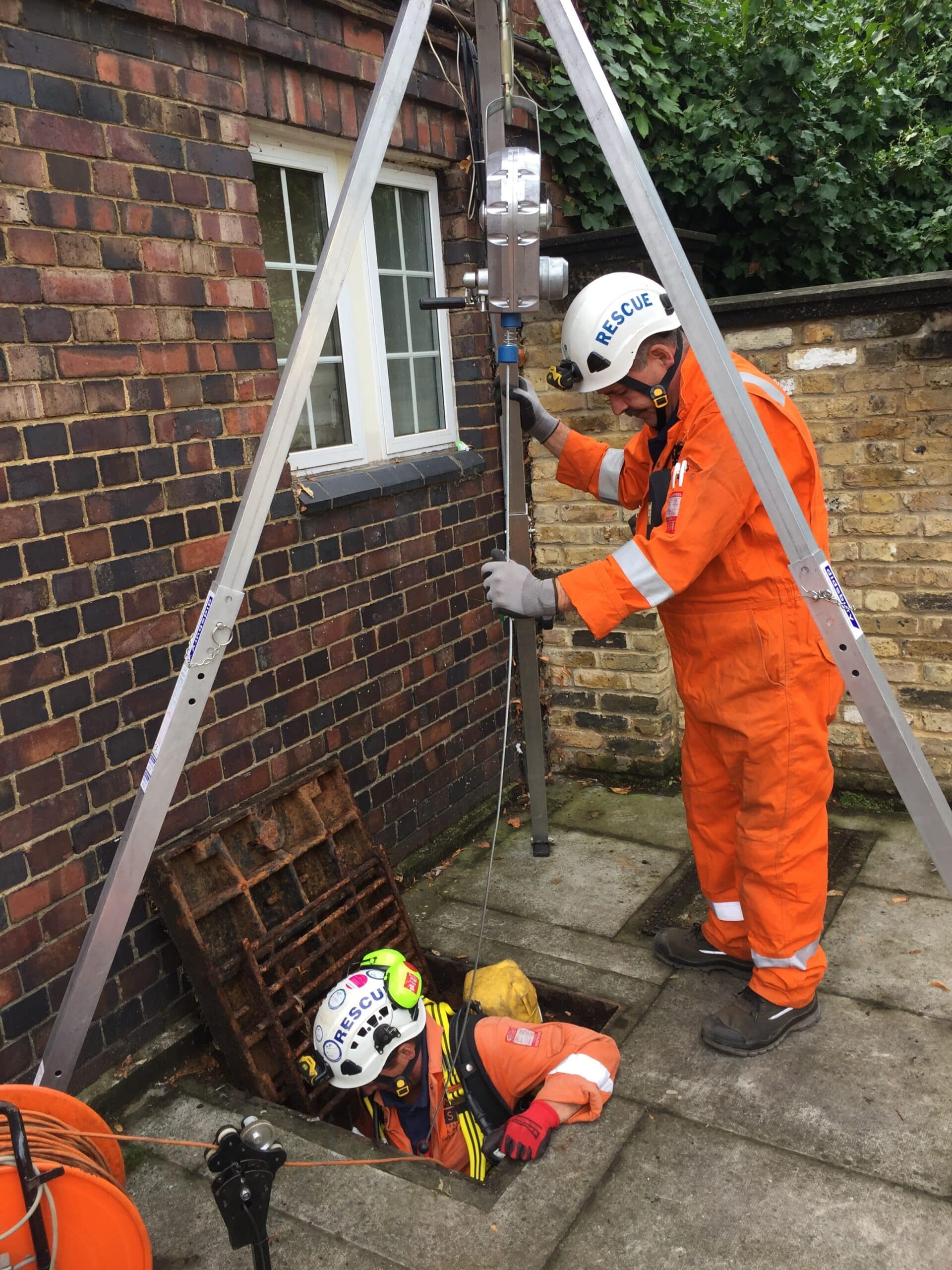
- Sondes: These are small electronic devices that, once inserted into the drainage system, emit a signal that can be traced above ground. Sondes are helpful for locating non-conductive utilities like plastic water pipes and fibre-optic cables. For this reason, they are usually used in conjunction with electromagnetic equipment to provide a complete picture.
- CCTV: Closed-Circuit Television systems are used to non-invasively inspect the condition of underground drainage systems. These surveys involve inserting a small camera into the drainage system to capture high-quality images of the interior. The footage is then examined to identify any defects or blockages that may be affecting the system's performance. CCTV inspection surveys will establish the condition before and after adoption of sewers and assist in the creation of maintenance programmes. The best inspection reports are prepared to National Water Council (NWC) standards. These consist of a coded report, photographic captures of significant defects, supporting drawings, and high-resolution videos in MPEG or AVI format. At Bury Associates, we also provide a digital presentation that links all of these elements in an accessible format.
How is an Underground Utilities Survey Delivered?
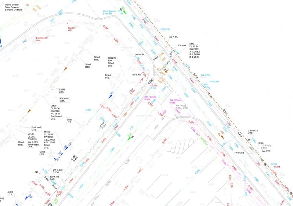
Once the surveyors have carried out an underground utility detection, the routes of the pipes, cables and drainage are marked on the ground before being recorded using Global Navigation Satellite System (GNSS) receivers and total stations. The routes and depths of the underground services can then be delivered as a 2D or 3D Computer-Aided Design (CAD) overlay as part of a topographical survey, or a 3D Revit model. This enables an understanding of how the underground utilities network relates to features on the surface.
For more information on how GNSS and total stations collect information on sites, please read our post on topographical survey equipment and technology.
How Much Does an Underground Utilities Survey Cost?
The price of an underground utilities trace depends on the project location and how much work is involved both on-site and in the office to produce the survey deliverables. As a general rule, prices start from around £800 + VAT. Our pricing guide will give you a good understanding of what you can expect to pay, as well as how Bury Associates calculate prices. However, the best way to get an understanding of costs is to request a free quote.
Conclusion
At Bury Associates, we recommend combining your topographical survey with an underground utilities trace. In doing so, you stand the best possible chance of avoiding costs associated with possible delays. For more information, contact us to get a free quote for your underground services survey.
Other Topographical Survey Guides
We will survey your Underground Utilities
Steve Bury is the Managing Director of Bury Associates, a land and measured building survey company based in the UK. With over 40 years of experience in surveying, Steve Bury established Bury Associates in 1997 to combine the provision of high quality digital surveys with exceptional customer service. Steve has also designed software applications for measuring buildings to automatically create survey drawings.