What is a Topographical Survey? A Complete Guide
Performing a topographic survey is fundamental to effectively planning both construction and land management projects. But what exactly is a topographical survey, and how does it work? How are land surveys crucial to preserving the natural environment? In this article, you'll learn everything you need to know.
Need a Topographical Survey?

Need a Topographical Survey Quote?
Topographical survey definition
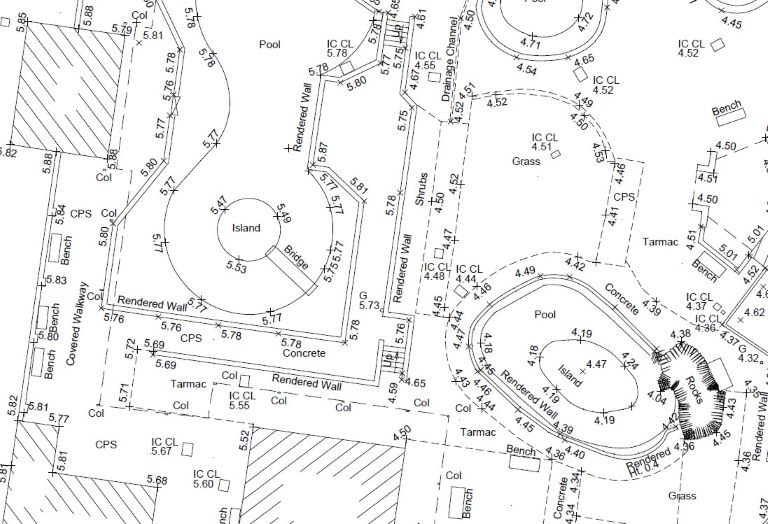
Also known as a topo or land survey, a topographical survey maps the features, elevation, and boundaries of a site. Survey instruments define the ground and its borders by measuring the relative distance between both man-made and natural fixtures, including fences, buildings, streams, and trees. Once captured, the data is configured to represent a three-dimensional perspective of the area in a selection of digital formats. These include computer-aided design (CAD) software, and Revit/BIM.
The information gathered in a land survey ties into the standardised framework offered by a national grid mapping system. In the UK, this refers to the Ordnance Survey. The integration of topo surveys into national co-ordinates ensures country-wide consistency.
What information does a topographical survey gather?
Examples of what information is collected in the survey include:
- Elevation and contours: by measuring the land's elevation points, surveyors create contour lines on a map, indicating the terrain's shape and slope.
- Natural features, such as hills, lakes, and streams, as well as vegetation types, forest densities, and significant singular entities like large trees.
- Man-made features, such as buildings, and fences.
- Property boundary lines and markers
- An underground utilities trace (locating water lines, gas lines, electrical cables, and sewage systems) alongside mapping surface utilities to supplement the information gathered.
- Surface water drainage patterns and features
- Topographic relief and terrain analysis, including slopes and depressions.
Types of topographic survey
Topgraphic surveys can take a variety of forms, the suitability of each depending on the purposes of the project. For example, while those seeking to know a site's boundaries may need only a basic outline survey, those intending to build require a detailed 3D model. Such complex designs are drawn-up in the office using CAD programs, such as AutoCad.
Certain projects may also call for an underground utility survey, which involves the tracing of gas and water pipes using ground-penetrating radar (GPR). Avoiding damage to underground utilities is necessary for avoiding repair costs, not to mention preventing injuries.
Please note that surveys can also be conducted in buildings. Termed a measured building survey, this maps out features such as floor plans, elevations, and sections. If you would like more information on this topic, read our detailed guide to measured surveys.
What equipment does a topographical survey require?
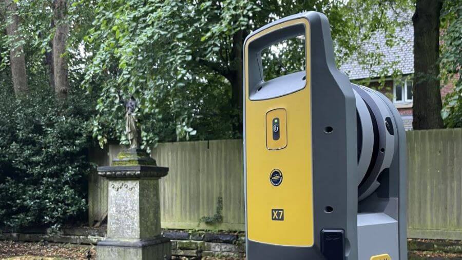
Primarily, surveyors use laser scanners, GPS equipment, and total stations to measure the land. Specific models they might employ include Trimble S6 Total Stations, Trimble X7 Laser Scanners, and Trimble R12i GNSS receivers. For larger or less accessible sites, the surveyor may also conduct a drone survey.
Discover more on this topic by reading our dedicated post on topographical survey equipment.
What are the objectives of a topographic survey?
By accurately mapping the topography of the site, a land survey enables engineers, architects, and planners to make informed decisions about the design and development of their projects. Among other considerations, an accurate land survey helps in identifying suitable building sites, planning road alignments, designing drainage systems, and landscaping. Conducting a survey in the first instance can prevent building on unsuitable areas. For example, a topographical survey can reveal whether the planned build encroaches on a boundary, thereby helping to prevent a dispute with the local council. As such, surveys are foundational to delivering polished, cost-effective construction work.
How long does a topographical survey take?
The complexity and size of the proposed site and project determine the duration of a topographical survey. Once the site has been surveyed, it usually takes a few days to draw up the data and send it over. The digital format of the survey - whether it appears in 2D or 3D - will depend on the level of detail the project calls for.
How accurate is a topographical survey?
The accuracy of a topographical survey is usually defined in the project specifications. Commonly, plans specified to high-precision require accuracies within a few centimetres.
The degree of accuracy in a topographical survey can vary based on several factors. One of these is the equipment used. At Bury Associates, we use a variety of modern survey equipment utilising GPS (Global Positioning System) and LiDAR (Light Detection and Ranging) technologies. This ensures the captured data is as representative of the actual site as possible. Other factors, mostly relating to the condition of the land, can sometimes affect the finished product. For example, both dense vegetation and heavy cloud cover can limit the efficacy of GPS. Since Bury Associates effectively plans for such mitigating circumstances, every survey we deliver is finished to a high standard.
Ready to take the first step?
Who carries out a topographic survey?
A topographic survey is undertaken by highly-qualified land surveyors who examine the land with specialist equipment. Back in the office, technicians transform the collected data into detailed digital drawings.
In the UK, land surveying is a valuable, coveted skill. At Bury Associates, our surveyors have a combined experience of over 50 years.
How much does a topographic survey cost?
The price of a topographical survey depends on the project location and how much work is involved - both on-site and in the office - to deliver the survey. In the UK, prices start from around £500 + VAT.
To gain a better understanding of what you can expect to pay and how costs are calculated at Bury Associates, see our dedicated article on the price of a topographic survey.
For the most accurate estimate, request a free quote.
Topographic survey example
Since its origins in 1997, Bury Associates has amassed a large project archive, detailing surveys in London and surveys around the UK.
In September 2022, we performed a topographical survey of Natureland Seal Sanctuary, where rescued seal pups are prepared for their release off the Lincolnshire coast. For this project, our surveyors used a combination of laser scanners and drones to capture precise details. Subsequently, the recorded data was transformed into a 3D Revit model. This was used in the planning of a partial redevelopment of the sanctuary.

Aerial view of Natureland Seal Sanctuary
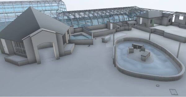
3D model of Natureland Seal Sanctuary
To find out about topographic surveys in your area, see surveys near me.
The role of topographical surveys in environmental conservation
Performing a topographical survey can be critical to environmental conservation efforts. In its identification of natural features, including water bodies and vegetation, a survey informs developers of the land's existing configuration. When making plans, then, the reference to a topographical survey can aid developers' accommodation of the natural environment.
Commonly, topographical surveys are performed when developments are proposed in areas with rich biodiversity or cultural heritage. Disputes between advocacy groups and local governments can sometimes be resolved through conducting a comprehensive survey of the land.
Future trends in topographical surveying
Technological advancements are continually shaping the field of topographical surveying. The future promises even greater precision and efficiency through innovations such as augmented reality (AR) for real-time data overlay and machine learning algorithms for automatic feature recognition.
Conclusion
Throughout history, surveying has defined how we understand the world around us. What was once an essential yet rudimentary practice, involving simply manpower and basic materials, has evolved into a technologically-advanced, near-perfect process. Even so, the same principles that guided ancient architects persist today: those of geometry, precision, and practice.
We can provide your topographical survey
Steve Bury is the Managing Director of Bury Associates, a land and measured building survey company based in the UK. With over 40 years of experience in surveying, Steve Bury established Bury Associates in 1997 to combine the provision of high quality digital surveys with exceptional customer service. Steve has also designed software applications for measuring buildings to automatically create survey drawings.