Why Measured Surveys Are Essential For Heritage Building Conservation
In this article, I will explain why a measured survey is the crucial first step in building conservation projects.
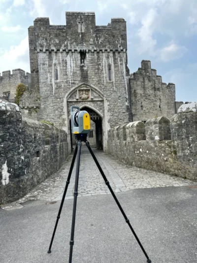
At Bury Associates, our survey services are requested for listed or otherwise historically-significant buildings that have been proposed for restoration. Over the years, we have conducted measured building surveys on numerous structures across the UK, from castles to centuries-old barns.
Why Does Heritage Conservation Matter?
Historical buildings are crucial to communities. Heritage structures signify an area's rich history, strengthening its charm and character. In fact, tourism boards are often built around an area's culture, imbued in no small part by its architectural inheritance. Where would Bath be without the Roman Baths or the magnificent Royal Crescent? What would adorn the postcards of Worcester if not its illustrious Cathedral? Undeniably, architectural structures come to define a location, gathering around them a unique culture that becomes symbolic of the place itself.
The importance of heritage buildings to communities in the UK cannot be overstated. Historical structures serve as living relics of a society's history and identity. The representation of the architectural styles and craftsmanship of the past through buildings creates a sense of place and continuity within the community. Heritage sites also function as venues for celebrations, exhibitions, and other social functions that bring people together. Not to mention, these architecturally unique buildings enhance the visual appeal of Britain's towns and cities. Every year, Britain attracts vast numbers of tourists to historic sites, providing significant benefits to its local economies.
Subjected to the ravages of time, buildings naturally diminish. But the projected occurrence of extreme weather events, fluctuating temperatures, and acid rain puts these delicate structures at increased risk. As such, the issue of how to protect Britain's architectural heritage has been pushed to the fore.
How Do We Preserve Buildings?
Protecting important structures for the benefit of future generations is a necessary objective. The preservation of these buildings can take a few different forms, including:
- Conservation: conservation focuses on preserving the existing material and structure of the building. This may involve stabilising deteriorated materials, consolidating fragile surfaces, and protecting against environmental factors like moisture, sunlight, and pollution.
- Restoration: restoration aims to return a building to its original condition or a specified period in its history. This often involves extensive research to understand the building's original design and construction methods, as well as careful repair or reconstruction of damaged or missing elements.
- Adaptive Reuse: rather than letting a historical building fall into disrepair or demolishing it, adaptive reuse involves finding new functions for the space while preserving its historic character. This could include converting a historic warehouse into loft apartments, turning an old schoolhouse into a community centre, or transforming a factory into office space.
Of course, these projects must be sensitive to the building's original construction. This may involve sourcing traditional materials such as lime mortar, historic bricks, or wooden beams, as well as keeping craftmanship consistent with the original style.
What Methods of Preservation Can We Use?
The measures we can take to develop a historical building vary:
- Structural Stabilisation: historical buildings often suffer from structural issues due to age, weathering, and past modifications. Strengthening and stabilising the structure through methods such as reinforcing foundations, repairing structural elements, and installing support systems can help ensure the building's long term stability.
- Weatherproofing and Waterproofing: protecting historical buildings from water infiltration and weather damage is essential for their preservation. This may involve repairing or replacing damaged roofs, gutters, and flashing, as well as applying appropriate sealants and coatings to exterior surfaces.
- Fire Protection: historical buildings are often more susceptible to fire due to ageing electrical systems, combustible building materials, and lack of modern fire protection measures. Installing fire suppression systems, upgrading electrical wiring, and implementing fire-resistant materials can help reduce the risk of fire damage while preserving the building's historic features.
- Accessibility Upgrades: ensuring accessibility of historical buildings for people with disabilities is extremely important. This might involve carefully integrating features such as ramps, elevators, and accessible toilets in a way that respects the building's architectural integrity.
We can all think of examples of historical structures that have been restored or repurposed, but we may neglect to consider the complex construction process behind the projects. Before undertaking any conservation effort, a measured survey service will be commissioned to obtain a comprehensive insight into the building as it currently stands. At Bury Associates, we have had surveys requested by such bodies as the Heritage Lottery Fund.
Why Are Measured Surveys Essential to Building Conservation Projects?
Altering historical buildings in the UK is complex. First, buildings designated as listed are subject to strict guidelines. Even once the owners have obtained the consents from local authorities or heritage bodies, the proposed changes must be conducted in a way that does not affect the character, and sometimes the appearance, of the building. It can be challenging for architects to design the proposed updates, like integrating modern amenities, while considering the building’s historical character. Balancing respect for historical features with meeting modern building codes and standards can pose technical challenges. Often, innovative solutions are required, which may need special approvals or expertise.
On the other hand, structural engineers face problems such as stabilising existing foundations without altering the building’s appearance. When materials have degraded, engineers often employ conservation-friendly techniques that aim to preserve as much of the original material as possible. For instance, rather than replacing a degraded timber beam, they might reinforce it internally, or use gentle cleaning techniques to restore surfaces without damaging them.
The complexity involved in heritage building conservation, influenced by factors like consultation of specialists and compliance with regulations, inevitably drives up costs and increases the duration of the project.
What a measured survey can provide is a thorough baseline that ensures as much as possible can be known about the building when making plans. Technologies like 3D laser scanning, ground-penetrating radar, and drone inspections help in understanding the extent of degradation and the structural integrity of the building without causing any damage. The creation of Building Information Models (BIM) reduces costs by improving collaboration. What is more, the impressive facades of heritage buildings can be analysed using 2D Computer-Aided Design (CAD) enhanced with Ortho-Images, which display any imperfections in the stonework.
At Bury Associates, we have cultivated a cutting-edge approach to measured surveys which combines terrestrial and drone-based photogrammetry, laser scanning, and reality capture techniques. These are all seamlessly integrated into Revit/BIM technology or are used to create highly detailed CAD drawings showing floor plans, elevations and sections. This innovative approach ensures that every detail of your heritage structure is captured in 3D, allowing an accurate understanding of how different floors relate to each other, the location of voids, and providing all the information needed for structural analysis.
You can have your heritage survey delivered in any digital format, such as CAD drawings, Reality Capture models, high resolution Ortho-Images and 3D Revit Models.
Case Study: Tonedale Mill, Wellington
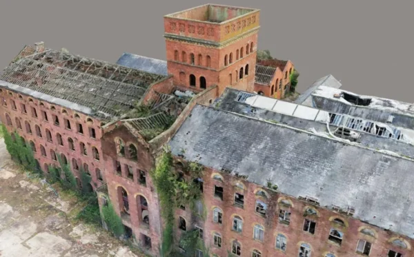
Tonedale Mill is a Grade II* listed former woollen mill near Wellington in Somerset, parts of which date back to the mid-18th century. Since halting production in the 1980s, the mill has been inactive. The site has changed hands several times over recent years, and attempts to convert some of the buildings into housing failed, leaving them in a state of considerable disrepair.
Historic England's Heritage at Risk funded Somerset West and Taunton Council who appointed a team consisting of Jubb Clews Chartered Surveyors for Historic Building Conservation, Mann Williams Consulting Structural Engineers, Press and Starkey Chartered Quantity Surveyors, and Bury Associates. The task Bury Associates undertook was to produce 3D photogrammetric models and drone survey data, during rapid assessment for urgent works and repairs notices.
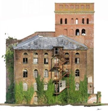
To ensure accuracy and capture every minute detail, Bury Associates employed advanced technology, drones photogrammetry, terrestrial photogrammetry, and GPS survey control. This approach resulted in comprehensive data, facilitating the creation of a highly detailed Context Capture 3D Photogrammetric Model.
Client Feedback
“The project required extremely quick data collection on site, both for the condition and metric surveys. The site was dangerous and the data collection technique of using drones and ContextCapture proposed by Bury Associates was deemed safer and quicker than using traditional methods. It produced accurate 3D models that allowed some of the condition appraisals to be carried out safely off site and provided accurate metric data for the cost study. The site was physically challenging. The Bury Associates team showed exemplary attention to detail and colleague care to ensure that safe working procedures were applied, and quickly processed the 3D model that has proved so useful”
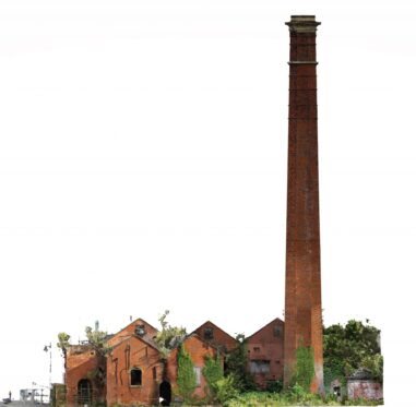
Project Deliverables
- ContextCapture 3D Photogrammetric Model - delivered as a web-based model viewable through any standard browser
- Ortho-Images of the building facades and roofs for the marking up of defects.
Ready to find out more?
Tell us about your project today
