
Topographical Surveys
A topographical survey, commonly referred to as a land survey, meticulously maps out the contours, levels, and intricate features of the land you're planning to develop. This invaluable document offers an accurate representation of your project site, showcasing the location of neighbouring buildings, trees, and drainage systems in a selection of digital formats. These include computer-aided design (CAD) and Building Information Modelling (BIM) software, such as Revit.
"The project required extremely quick data collection on-site, both for the condition and metric surveys. The site was dangerous and the data collection technique of using drones and ContextCapture proposed by Bury Associates was deemed safer and quicker than using traditional methods. It produced accurate 3D models that allowed some of the condition appraisals to be carried out safely off-site and provided accurate metric data for the cost study. The site was physically challenging. The Bury Associates team showed exemplary attention to detail and colleague care to ensure that safe working procedures were applied, and quickly processed the 3D model that has proved so useful”
Lynda Jubb
Jubb Clews
"We’ve recently used Bury (not my first experience of the company) for a laser survey and Revit model output; first rate communication, responses and modelling, all within my allotted timescales. Perfect service, massive thanks to Steve and his team. We’ll be back…"
Corporate Architecture
“I have worked with Bury Associates on a number of projects. They have always been a pleasure to deal with, are always helpful and are prompt in turning around information.”
Frankie Levey
Rigby & Rigby
"Bury Associates have carried out multiple measured surveys, issuing 2D drawings, 3D models and providing point cloud data which has been all essential as Marylebone Cricket Club considers the future development and ongoing enhancement of Lord's Cricket Ground. Surveys have always been carried out in good time and the information issued swiftly following the completion of each survey."
Jay Neil, Associate Director
Gardiner & Theobald
"Bury Associates have carried out a number of surveys for Peel recently and I have found them to be very responsive, provide an excellent professional service and are good value for money. They are flexible and able to provide surveys in a number of different formats to suit each project and I would not hesitate to use them in the future"
Roger Wheeldon, Director of Development
Peel Holdings

Drone Topographical Surveys
For larger areas, Bury Associates' skilled topographical surveyors carry out drone aerial mapping surveys that are accurately controlled on the ground by survey-grade GPS/GNSS. These surveys are supplemented by terrestrial surveys and laser scanning to guarantee accuracy and full cover.
Underground Services Tracing
The layout of the underground services on your site will also be crucial to your project. Using radio detection equipment and ground-penetrating radar, we carry out utility surveys for you to map out all the pipes and cables below your site. These underground services will be shown as separate layers on your survey so they can easily be avoided, moved, or connected to.

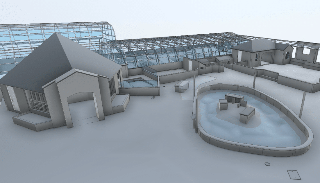
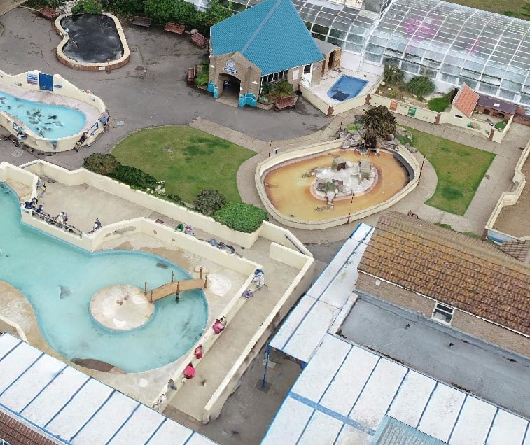
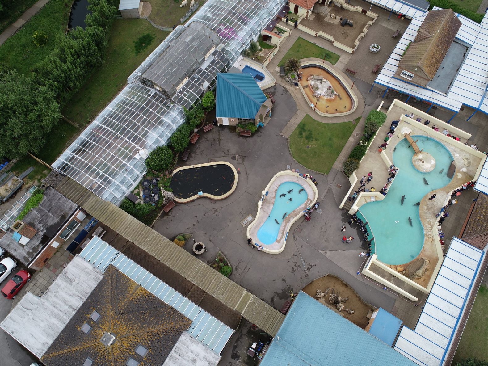
project spotlight
Bury Associates were commissioned to carry out a Topographical and Measured Building Survey of Natureland Seal Sanctuary
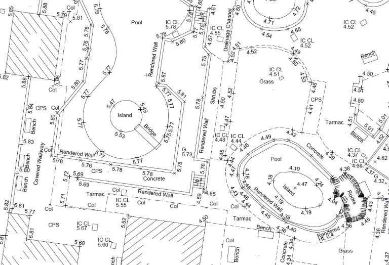
What Does a Topographical Survey Provide?
A topographic survey is a highly detailed, centimetre-accurate map of site. It includes topographic features such as buildings, manhole covers, service covers, drainage points, lampposts, telephone poles, individual trees, steps, walls, and fences, along with descriptions of topography, surfaces, levels, and heights. Moreover, it often encapsulates additional information like surrounding buildings and the location of underground services. With GNSS/GPS, we correlate your topographical land survey along with its site levels and coordinates to the Ordnance Survey National Grid.
We provide your land survey in a digital format of your choice, including 2D CAD, 3D CAD, PDF, or Revit.
Precision and Detail: Expert Topographic Land Surveyors
The success of your site project relies heavily on a precise and reliable topological survey. At Bury Associates , we specialise in providing highly detailed survey solutions such as land and topographical surveys, displaying features, levels, and contours with exceptional clarity and accuracy.
Before you commence design work or plan alterations to your site, it's crucial to understand what's already in place: the site's boundaries, the relation between different levels, and the existing elements on your site. Our topographical GPS surveys ensure you have site coordinates based on Ordnance Survey datum and grid.
3D Mapping for a Clearer Site Perspective
We use state-of-the-art technology, including laser scanners, GPS, and drones, to measure your site in 3D, resulting in measured surveys that offer comprehensive data suitable for planning a successful project on any area of land. Our approach ensures every detail of your site is measured accurately in 3D, providing a reliable foundation for your design work.
Bury Associates is your partner in all your topographical survey needs, ensuring precision and reliability.
What our clients say
Topographical Survey FAQs
Our Full Range of Services
Matterport Tours
Providing you with a 3D walkthrough tour of your site
Measured Surveys
Floor plan, sections, & elevations in high detail 2D drawings & 3D models
Drone Inspections
Providing you with aerial inspections & surveys for inaccessible areas
Underground Utilities
Using radio detection equipment & GPR to scan underground services
Setting Out
Setting out boundaries, structures, & steelwork, & monitoring movement
Reality Capture
Photo-Realistic 3D model showing every detail for heritage projects