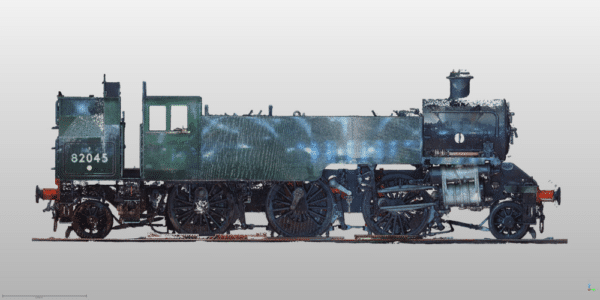
Our Blog

Church Organ Internal Elevation

What drawings do we need for a church reordering project?

By Steve Bury | Oct 3, 2025

Church reordering projects are exciting, complex and highly scrutinised. Whether you’re removing pews, improving accessibility, introducing a servery or weaving new services through an ancient fabric, success rests on one thing: robust, accurate drawings. Here’s a clear guide to the drawings you’ll need, why they matter, and how a measured building survey using laser scanning…

Read More
Trimble R12i for Borehole Surveys

Borehole Position Surveys

By Steve Bury | Oct 3, 2025

Borehole surveys are the backbone of effective site investigation. Your project depends on accurate, safe positioning of every borehole, trial pit and monitoring well. This is where our use of the Trimble R12i GNSS receiver proves valuable. It delivers reliable coordinates on busy, obstructed and uneven sites, fast. Why borehole positioning can be tricky On…

Read More
Scanner in Scaffolding

Scaffolding & Surveys: How to Avoid Delays, Cut Costs, and Get It Right First Time

By Steve Bury | Sep 29, 2025

You’ve got a building to develop, restore or redesign – and you need accurate elevation surveys. But there’s a problem: scaffolding is already up. Netting and sheeting are in place. Time is tight. You’re wondering: “Can we still get this surveyed?”   Yes, usually. But it may take longer, cost more, and miss critical details…

Read More
A scanner in a development. Part of the process in the creation of a topographical survey.

Do I need a topographical survey for planning permission in 2025?

By Steve Bury | Sep 20, 2025

Wondering “Do I need a topographical survey for planning permission in 2025?” In most cases, yes-or at least you’ll benefit greatly from having one before you submit. A topographical survey verifies that your proposed design fits within the site boundaries and existing conditions. It pinpoints the exact location of underground utilities, the positions of existing…

Read More

How AI Helps Architects See Buildings More Clearly

By Steve Bury | Nov 26, 2024

At Bury Associates, we are committed to providing cutting-edge tools and services that help our customers to envision, design, and deliver projects with confidence. Recently our integration of Matterport’s new Defurnishing AI feature into our services has caused quite a stir! This groundbreaking technology allows architects to instantly visualise any building as if it were…

Read More
charging an electric car

EV Charging Point Surveys

By Steve Bury | Aug 14, 2024

How Bury Associates can help you with your EV Charging Point installation using Laser Scanning and Underground Utilities Surveys.

Read More
topographical survey of a churchyard

Heritage Surveys for Adaptive Reuse

By Steve Bury | Jul 31, 2024

Find out why heritage surveys play an important role in adaptive reuse – redesigning historic buildings for new, creative purposes.

Read More
topographical survey in the midlands

How to Add Heights to Hundreds of Trees At Once In n4ce Using Point Clouds

By Steve Bury | Jul 24, 2024

To level up your topographical surveys, we’re showing you how to add heights to hundreds of trees at once using laser point clouds in n4ce.

Read More
matterport tour birmingham botanical gardens

How Do We Survey Botanical Gardens?

By Steve Bury | Jul 3, 2024

Expounding the transformation project planned for Birmingham Botanical Gardens and the role we have played in ensuring its success.

Read More